


RESEARCH


📚 Representative Works
* Staying the mouse over the screen stops the movement
Fire Risk Assessment
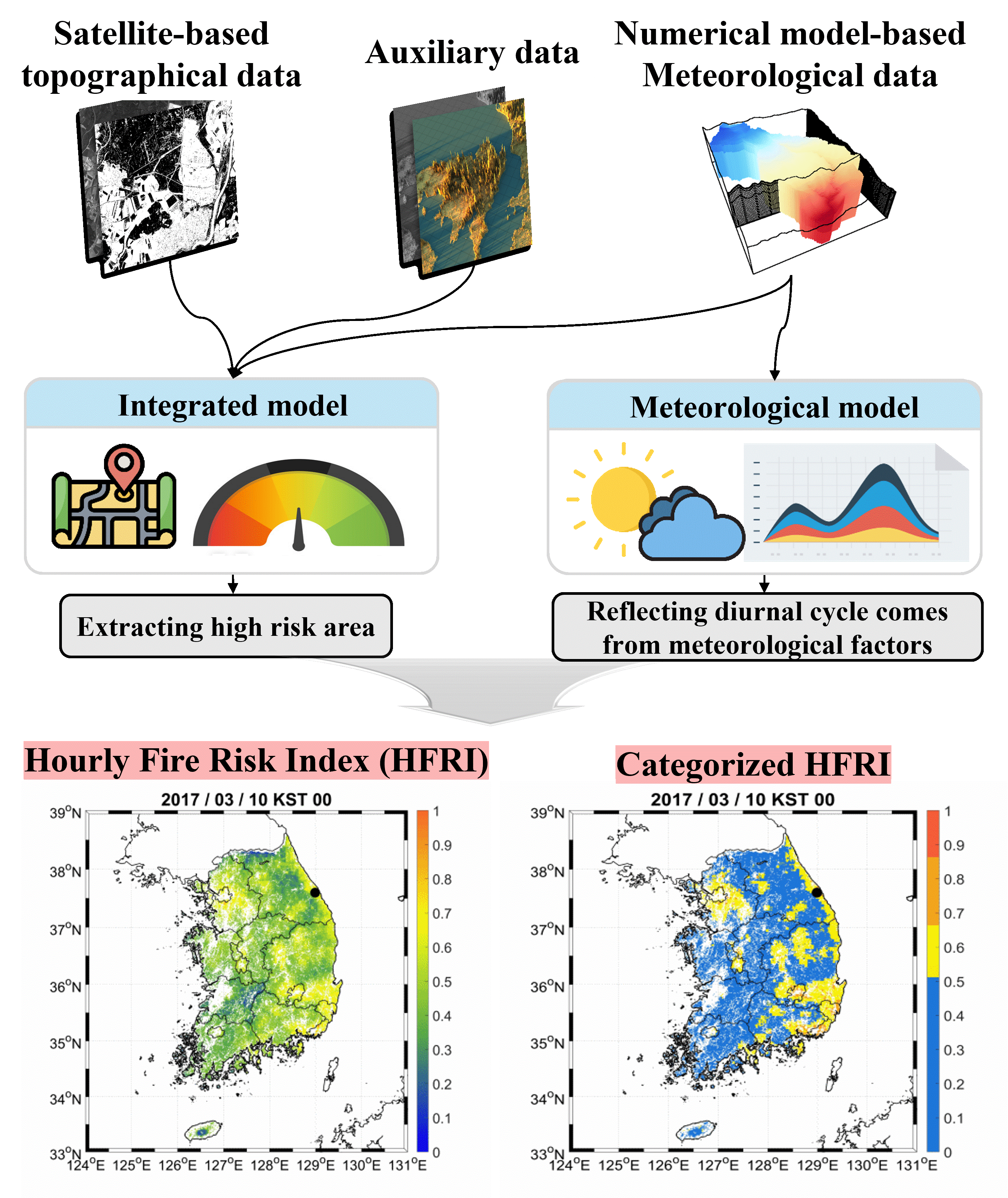
Wildfires can cause extensive damage, including deforestation and environmental pollution, even from a single event. Restoring affected areas requires substantial time and resources. Therefore, assessing wildfire risk in advance is essential for effective preparedness and response. Most existing wildfire risk indices primarily rely on weather variables associated with ignition, while comprehensive analyses incorporating diverse environmental factors remain limited.
Kang et al. (2019, 2020) addressed this limitation by developing an hourly forest fire risk index (HFRI) at 1 km resolution for South Korea. The index integrates accessibility, fuel, temporal, and meteorological factors using the CatBoost machine learning algorithm. HFRI was constructed from an ensemble framework combining integrated and meteorological models, enabling more spatially detailed and seasonally stable simulations compared to earlier indices. Feature contributions analyzed using Shapley Additive Explanations (SHAP) revealed that relative humidity, elevation, road density, and population density were key drivers, underscoring the critical role of accessibility in human-induced wildfire risk.
Kang et al., 2019
Kang et al., 2020
📝 Publications
Last updated : 2026/03/08
Rana, S. S., Lee, J., Kang, Y., & Im, J. (2026). Exploring the impacts of dual-polarized vegetation indices and U-shaped deep learning architectures on SAR-based burned area mapping. International Journal of Applied Earth Observation and Geoinformation, 146, 105141.
Kang, Y., Lee, J., & Im, J. (2026). Comprehensive global fire radiative power evaluation by minimizing detection bias with intercomparison and extended triple collocation analysis. Remote Sensing of Environment, 333, 115136.
Sung, T., Lee, G., Kim, D., Kim, W., Yang, S., & Im, J. (2025). Real-Time Wildfire Monitoring via Geostationary Satellite andArtificial Intelligence: Insights from the March 2025 South Korea Wildfires. Korean Journal of Remote Sensing, 41(3), 565-580.
Sung, T., Kang, Y., & Im, J. (2024). Enhancing Satellite-based Wildfire Monitoring: Advanced Contextual Model Using Environmental and Structural Information. IEEE Transactions on Geoscience and Remote Sensing.
Kang, Y., & Im, J. (2024). Mitigating underestimation of fire emissions from the Advanced Himawari Imager: A machine learning and multi-satellite ensemble approach. International Journal of Applied Earth Observation and Geoinformation, 128, 103784.
Kang, Y., Choi, H., Kim, Y., & Im, J. (2024). Understanding the Impact of Forest Fire on Ambient Air Quality. Journal of Korean Society for Atmospheric Environment, 40(1), 103-117.
Kang, Y., Sung, T., & Im, J. (2023). Toward an adaptable deep-learning model for satellite-based wildfire monitoring with consideration of environmental conditions. Remote Sensing of Environment, 298, 113814.
Lee, S., Kang, Y., Sung, T., & Im, J. (2023). Efficient Deep Learning Approaches for Active Fire Detection Using Himawari-8 Geostationary Satellite Images. Korean Journal of Remote Sensing, 39(5_3), 979–995.
Janizadeh, S., Bateni, S. M., Jun, C., Im, J., Pai, H. T., Band, S. S., & Mosavi, A. (2023). Combination four different ensemble algorithms with the generalized linear model (GLM) for predicting forest fire susceptibility. Geomatics, Natural Hazards and Risk, 14(1), 2206512.
Park, S., Son, B., Im, J., Kang, Y., Kwon, C., & Kim, S. (2022). Development of Mid-range Forecast Models of Forest Fire Risk Using Machine Learning. Korean Journal of Remote Sensing, 38(5_2), 781–791.
Kim, B., Lee, K., Park, S., & Im, J. (2022). Forest Burned Area Detection Using Landsat 8/9 and Sentinel-2 A/B Imagery with Various Indices: A Case Study of Uljin. Korean Journal of Remote Sensing, 38(5_2), 765–779.
Kang, Y., Jang, E., Im, J., & Kwon, C. (2022). A deep learning model using geostationary satellite data for forest fire detection with reduced detection latency. GIScience & Remote Sensing, 59(1), 2019-2035.
Lee, J., Kim, W., Im, J., Kwon, C., & Kim, S. (2021). Detection of Forest Fire Damage from Sentinel-1 SAR Data through the Synergistic Use of Principal Component Analysis and K-means Clustering. Korean Journal of Remote Sensing, 37(5), 1373-1387.
Sim, S., Kim, W., Lee, J., Kang, Y., Im, J., Kwon, C., & Kim. S. (2020). Wildfire Severity Mapping Using Sentinel Satellite Data Based on Machine Learning Approaches. Korean Journal of Remote Sensing, 36(5), 1109-1123.
Kang, Y., Jang, E., Im, J., Kwon, C., & Kim, S. (2020). Developing a New Hourly Forest Fire Risk Index Based on Catboost in South Korea. Applied Sciences, 10(22), 8213.
Kang, Y., Park, S., Jang, E., Im, J., Kwon, C., & Lee, S. (2019). Spatio-temporal enhancement of forest fire risk index using weather forecast and satellite data in South Korea. Journal of the Korean Association of Geographic Information Studies, 22, 116–130.
Park, S., Son, B., Im, J., Lee, J., Lee, B., & Kwon, C. (2019). Development of Satellite-Based Drought Indices for Assessing Wildfire Risk. Korean Journal of Remote Sensing, 35(6), 1285-1298.
Park, H., Im, J., & Kim, M. (2019). Improvement of satellite-based estimation of gross primary production through optimization of meteorological parameters and high resolution land cover information at regional scale over East Asia. Agricultural and Forest Meteorology, 271, 180-192.
Jang, E., Kang, Y., Im, J., Lee, D. W., Yoon, J., & Kim, S. K. (2019). Detection and monitoring of forest fires using Himawari-8 geostationary satellite data in South Korea. Remote Sensing, 11(3), 271.
Lee, J., Im, J., Kim, K., & Quackenbush, L. J. (2018). Machine learning approaches for estimating forest stand height using plot-based observations and airborne LiDAR data. Forests, 9(5), 268.
Fang, F., Im, J., Lee, J., & Kim, K. (2016). An improved tree crown delineation method based on live crown ratios from airborne LiDAR data. GIScience & Remote Sensing, 53(3), 402-419.
Li, M., Im, J., Quackenbush, L. J., & Liu, T. (2014). Forest biomass and carbon stock quantification using airborne LiDAR data: A case study over Huntington Wildlife Forest in the Adirondack Park. IEEE Journal of Selected Topics in Applied Earth Observations and Remote Sensing, 7(7), 3143-3156.